

Living in Bleasby: A Local Area Guide
Bleasby is an attractive Trent Valley village between Nottingham and Newark, close to Southwell, Fiskerton, Thurgarton, Hoveringham and Lowdham. Its railway station, village school, historic church, riverside walks and surrounding countryside make it one of the most appealing rural locations within the NG14 postcode.
The village has a varied housing market that includes period cottages, substantial detached homes, bungalows, family houses and individual properties on generous plots. Bleasby is especially popular with families, professionals, rail commuters, downsizers, heritage buyers and anyone looking for a quieter setting with access to Southwell, Nottingham, Newark and the River Trent.


About Bleasby
Bleasby is a rural village and civil parish in the Newark and Sherwood district of Nottinghamshire. It lies within the Trent Valley, approximately four miles from Southwell, around ten miles from Newark and within practical reach of Nottingham.
The parish has an unusual settlement pattern, with several distinct residential areas separated by open fields. The main village extends along the road between the railway station and the historic centre around St Mary's Church, Glebe Field, the village hall and the Waggon and Horses.
Bleasby combines a genuine countryside setting with useful amenities for a village of its size. Its own station, primary school, community facilities and access to the River Trent all strengthen its appeal to buyers seeking rural life without complete isolation.
History and local character
Bleasby has developed as a rural Trent Valley settlement surrounded by farmland, hedgerows and mature trees. The historic core contains many of the village's older houses and community buildings.
St Mary's Church
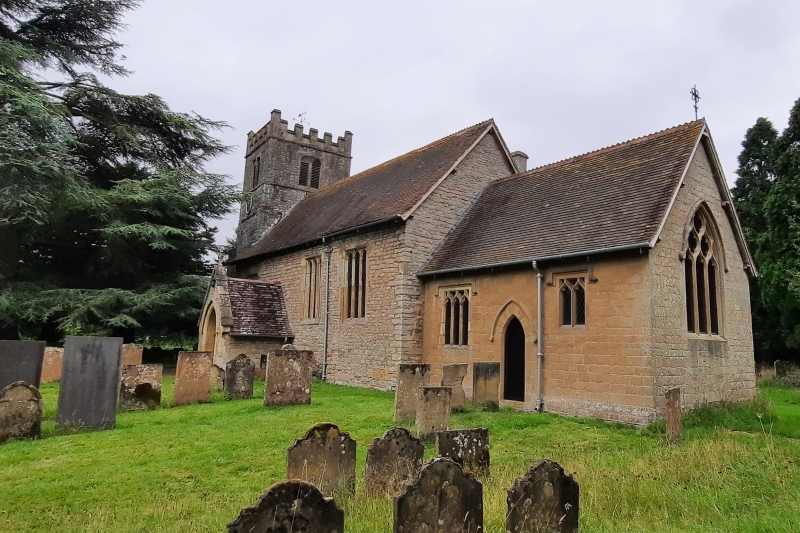
St Mary's is a Grade II listed parish church dating from the thirteenth century. It was restored during the nineteenth century and stands beside Glebe Field in an attractive churchyard at the centre of the old village.
Glebe Field and the village centre
Glebe Field acts as Bleasby's village green and sits close to the church, war memorials and village hall. This part of Bleasby creates the strongest sense of a traditional village centre.
Hazelford Ferry
Ferry End marks the historic location of Hazelford Ferry, once an important River Trent crossing. Written references to the ford and ferry stretch back many centuries, and the riverside remains an attractive place for walking and enjoying views across the valley.
Railway heritage
Bleasby station opened during the nineteenth century and remains an important part of village life. The railway helped connect Bleasby with Nottingham, Newark and the wider region while the parish retained its rural character.
Location and surrounding area
Bleasby lies between Nottingham and Newark, close to Fiskerton, Thurgarton, Hoveringham, Lowdham and Southwell. The River Trent runs through the surrounding landscape, while the A612 and A46 provide wider road connections.
This position is useful for households working in Nottingham, Newark or Southwell and for buyers who want access to countryside, riverside walks and village life.
Local amenities and everyday life
Bleasby has a useful range of local facilities, including a primary school, railway station, village hall, church, pub, playgroup, recreation spaces and active community groups. Southwell, Lowdham and Newark provide broader shopping and healthcare choices.
🍽️ Waggon and Horses
A traditional village pub located close to the historic centre.
🏛️ Village Hall
A former school building now used for meetings, groups and village events.
🌿 Glebe Field
An attractive green space beside St Mary's Church and the war memorials.
🛍️ Nearby services
Southwell, Lowdham and Newark provide supermarkets, healthcare and wider amenities.
Village community
Bleasby has a particularly active community, with local history, walking, cycling, environmental, wellbeing and social groups. The school, parish council, village hall and volunteer organisations all contribute to a strong local identity.
Shopping and healthcare
Everyday needs can be met locally or in neighbouring villages, while Southwell and Lowdham offer pharmacies, GP services, independent shops and supermarkets. Newark provides a much wider range of retail, leisure and professional services.
Schools and childcare
Bleasby Church of England Primary School is located on Station Road and serves children aged four to eleven. The school is part of the Minster Trust for Education and describes itself as a village school surrounded by countryside.
The school is linked with The Minster School in Southwell for secondary education, although admissions, catchments and available places must always be checked for the exact property address.
Transport and commuting
Bleasby's railway station is one of its strongest practical advantages. Road access towards Southwell, Lowdham, Nottingham and Newark also supports regional commuting.
Rail travel
Bleasby station is managed by East Midlands Railway and lies on the Nottingham–Lincoln line. Services connect the village with Nottingham and Newark, with onward connections available to a wider range of destinations.
Road connections
Local roads connect Bleasby with Southwell, Fiskerton, Thurgarton, Hoveringham and Lowdham. The A612 provides access towards Nottingham and Newark, while the A46 is within reach for longer journeys.
Bus services
Bus provision is more limited than in larger towns, so anyone relying on buses should check current routes, stop locations and frequencies for the exact property.
Walking and cycling
Public footpaths connect Bleasby with the River Trent, Hazelford Lock and neighbouring villages. The flat Trent Valley landscape is also attractive for recreational cycling.
Homes and property in Bleasby
Bleasby has a varied but relatively limited property market. Housing includes cottages, substantial period homes, detached family houses, bungalows, converted buildings and later residential development.
Property values can vary substantially according to road, plot size, condition, parking, outlook, proximity to the station and relationship with the River Trent or floodplain.
🏘️ Period cottages
Character homes concentrated around the older parts of the village.
🏡 Family houses
Detached and semi-detached homes with gardens and practical village access.
🔑 Individual properties
Larger homes, converted buildings and one-off houses on generous plots.
🛏️ Bungalows
Popular with downsizers and buyers seeking single-storey village living.
Rail-connected village demand
Homes within practical reach of the station can attract professionals and commuters seeking rural surroundings with access to Nottingham and Newark.
Riverside and rural considerations
Bleasby's Trent Valley location is central to its appeal, but buyers must carefully assess flood risk, drainage, insurance, access and the property's exact position. Risk can differ significantly between streets and individual plots.
Points for buyers to consider
- Environment Agency flood-risk information and historic flooding
- Building insurance availability and excesses
- Drainage systems, watercourses and surface-water risk
- Railway proximity and potential noise
- Parking and access on older village lanes
- Condition and energy efficiency of period homes
- School admissions and transport requirements
Green spaces and things to do
Bleasby's strongest lifestyle features are its countryside, riverside setting and community green spaces. Southwell, Lowdham and Newark add cultural, retail and leisure choices within a short journey.
🌊 Ferry End
A public riverside space at the historic Hazelford Ferry crossing.
🚶 Hazelford Lock walks
Riverside routes lead towards Hazelford Lock, Fiskerton and Gunthorpe.
🌿 Glebe Field
The village green beside St Mary's Church and the historic centre.
🚴 Trent Valley cycling
Quiet lanes and flatter terrain suit recreational cycling through neighbouring villages.
Who is Bleasby best suited to?
Families
A village primary school, community facilities and family housing support everyday life.
Rail commuters
The station provides connections towards Nottingham and Newark.
Professionals
Rural surroundings combine with practical access to regional employment centres.
Upsizers
Detached homes and individual properties may provide larger gardens and plots.
Downsizers
Bungalows and smaller period homes allow buyers to remain in a village environment.
Outdoor households
River walks, countryside and cycling routes suit walkers, cyclists and dog owners.
Woodstead's view of Bleasby
Bleasby is one of NG14's most balanced villages. It offers a genuine rural setting, attractive period property, a strong community and its own railway station, while Southwell, Lowdham, Nottingham and Newark remain accessible.
We would expect strongest demand for well-presented detached family homes, period cottages, bungalows in quieter positions and properties within practical reach of the station or the village school.
Pricing should be highly property-specific. Flood risk, exact position, plot, parking, railway relationship, condition and outlook can all materially affect demand and value. Two homes within the same village may therefore require very different strategies.
Bleasby property market
A limited-supply Trent Valley market shaped by rail access, family demand, village character, individual homes and careful assessment of flood and drainage considerations.
Family houses with parking and gardens attract buyers moving from Nottingham and nearby towns.
Cottages and older homes appeal when character is supported by good maintenance and presentation.
Station proximity strengthens demand from commuters travelling towards Nottingham and Newark.
Limited supply can create strong interest from downsizers and local movers.
Clear information on risk, insurance and resilience can be important to buyer confidence.
Exact road, plot, condition, outlook and risk profile matter more than a broad NG14 average.
Bleasby area guide FAQs
Moving to or from Bleasby?
Woodstead helps buyers, sellers and landlords across Bleasby and the wider NG14 area. Our team can advise on period cottages, detached family homes, bungalows, individual properties and local pricing strategy.
View properties for sale Book a free valuation